Hiking routes
If you are looking for trekking in Malaga and to discover the nature diversity in the area, the Malaga mountains are a very recommended choice. Inside the park, there are 150 km of forest paths, of which 45 km are passable and in good condition.
Through the park are running ten itineraries which are proposed below. Itineraries 2, 5, 6 and 7 are passable to vehicles, though at times some of them remain closed, allowing access only by foot.
- Hiking route 1: Molinos de San Telmo - El Boticario.
In Los Molinos de San Telmo, next to the sanatorium of San Jose, past the houses we find a gate; here begins the journey to our right along Arroyo Hondo. It is a dangerous area in which the Fire Department has had to intervene at times to rescue people plunged into the ravine.
- Lane open to traffic
- Length: 7 kms - Hiking route 2: El Boticario - El Cerrado.
Start at the Regional Road 345, Km.551, 950. Next to the inns of "El Mijeño" and "El Boticario"
- Lane open to traffic
- Length: 12,7 kms - Hiking route 3: Don Ventura - El Cortijillo.
Start at the intersection with route #1 at km 3.80
- Lane open to traffic
- Length: 11,85 kms - Hiking route 4: El Cortijillo - Supide.
Start at the intersection with route #2 at km 8
- Lane open to traffic
- Length: 9,75 kms - Hiking route 5: Las Contadoras - Don Timoteo - Jotrón
Begin to the left of the landmark that is at km 2.17 km of route No. 6. At about 100 meters to the left is a gate of entry to "Las Contadoras". Continue straight ahead.
- Lane open to traffic
- Length: 3,35 kms - Hiking route 6: Fuente de la Reina - Torrijos.
It starts at Km 545.600 of the county road 345, to the left of the fountain of the Queen (Fuente de la Reina).
- Lane open to traffic
- Length: 8,89 kms - Hiking route 7: Serranillo - Carretera Comarcal 345.
Start at the intersection with route No. 6 at km 4.46. Behind us the ruins of the winery Santillana. At 200 mts to our right, on top of a hill the winepress of Chinchilla.
- Lane open to traffic
- Length: 8,10 kms
- Hiking route 8: Torrijos - Cocherilla del Dorador.
Start at the intersection with route No. 6 at km 7.19 near Torrijos.
- Lane closed to traffic
- Length: 6,40 Kms - Hiking route 9: Maruján - El Dorador.
Start at the Regional Road 345 at km 538.180. Access is blocked by a padlocked chain.
- Lane closed to traffic
- Length: 7,07 Kms - Hiking route 10: Venta El Pinar - Lo Calvo - El Dorador.
Start behind El Pinar inn, located at km 536.70 of the local road 345. The access is blocked by a padlocked chain.
- Lane closed to traffic
- Length: 10,55 Kms
Hiking is a wonderful way for discovering the nature and the beauty of the place we visit. Also do not forget to savour the delicious typical dishes of this region in Malaga.

 Pueblos Blancos Music Festival 2019 – Festival in White Villages
 Highlights,facts and curiosities of Sierra Nevada in Granada
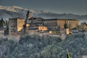 Alhambra in Granada: A Thousand and One Nights